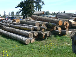
Carlsborg was founded in 1915 by C.J. Erickson, and named after his hometown in Sweden.[3] Its sawmill discontinued operations in 1968.
(from ^ Majors, Harry M. (1975). Exploring Washington. Van Winkle Publishing Co. p. 15. ISBN 9780918664006.)
Carlsborg had its beginning in August of 1915 with the construction of a shingle mill and a sawmill. A wealthy Seattle builder, C. J. Erickson, acquired large tracts of fine timber in the Lost Mountain and Indian Valley areas south of Sequim. Erickson built the mills at a site four miles west of Sequim next to a railroad and named the operation Carlsborg Mill and Timber Company.
A settlement grew up around the mill and Erickson named the new town Carlsborg after Karlsborg, Vastergotland, a town in Sweden where he had once lived.
Railroad tracks were laid heading in a SSW direction until they began running alongside McDonald Creek. The main mill, shingle mill, and log pond were constructed on an 87-acre site. Initially, the mill was designed to have a daily output of 50mbf, but would later be upgraded to produce 100mbf.
The town of Carlsborg grew and its businesses thrived. By the mid-1930s, the declining market for lumber caused Erickson to sell the mills. The buyer was a partnership with Lou Hubbard, W. Washburn, Victor Soderberg, Nichols and Trumbull being the five partners involved.
In 1936, the partnership sold the mill to a Seattle firm, which intended to scrap it. However, in Jan 1937, the mill was reopened when Lawrence McLellan, Harry O’Donnell and William Westover purchased it. They operated it until 1942, and sold it to Crescent Logging Company.
When the timber cut in the Lost Mountain was finished, the company fed the mill with logs from their Sol Duc holdings by way of the Port Angeles and Western, and trucked in anything else. The Carlsborg tracks were torn up and the lines were abandoned some time later.
In 1967, the mills closed forever, and the buildings torn down. The mill pond was filled in and became a travel park. Many of Carlsborg’s residents drifted away. Still, a core of homeowners and essential services remained – a post office, general store, school, church, and a tavern, and over time, the town would begin to grow again.
REFERENCES:
Portions from www.ghosttowns.com/states/wa/carlsborg.html – Submitted by Henry Chenowith.
Portions from http://www.trestlewalker.com/CarlsborgMandTCo.html.
According to the United States Census Bureau, the CDP has a total area of 1.0 square miles (2.5 km²), all of it land.
Demographics for Carlsborg, WA
As of the census of 2000, there were 855 people, 427 households, and 263 families residing in the CDP. The population density was 883.8 people per square mile (340.3/km²). There were 461 housing units at an average density of 476.6/sq mi (183.5/km²). The racial makeup of the CDP was 94.74% White, 1.40% Native American, 0.82% Asian, 0.70% from other races, and 2.34% from two or more races. Hispanic or Latino of any race were 1.64% of the population.
There were 427 households out of which 13.3% had children under the age of 18 living with them, 54.1% were married couples living together, 5.2% had a female householder with no husband present, and 38.4% were non-families. 34.7% of all households were made up of individuals and 22.2% had someone living alone who was 65 years of age or older. The average household size was 2.00 and the average family size was 2.51.
In the CDP the population was spread out with 14.7% under the age of 18, 3.3% from 18 to 24, 13.5% from 25 to 44, 20.0% from 45 to 64, and 48.5% who were 65 years of age or older. The median age was 64 years. For every 100 females there were 92.6 males. For every 100 females age 18 and over, there were 86.4 males.
The median income for a household in the CDP was $28,103, and the median income for a family was $36,736. Males had a median income of $25,455 versus $16,618 for females. The per capita income for the CDP was $17,350. About 3.6% of families and 7.5% of the population were below the poverty line, including 7.2% of those under age 18 and none of those age 65 or over.
(from http://en.wikipedia.org/wiki/Carlsborg,_Washington)
According to the United States Census Bureau, the CDP has a total area of 1.0 square miles (2.5 km²), all of it land.
Country United States
State Washington
County Clallam
Area
– Total 1.0 sq mi (2.5 km2)
– Land 1.0 sq mi (2.5 km2)
– Water 0.0 sq mi (0.0 km2)
Elevation 180 ft (55 m)
Population (2000)
– Total 855
– Density 883.8/sq mi (341.3/km2)
Time zone
Pacific (PST) (UTC-8)
Summer (DST) PDT (UTC-7)
ZIP code 98324
Area code(s) 360

